I don't know much about volcanoes. Am I correct in thinking that even though Mauna Loa is the largest volcano on Earth, this eruption is not a global threat in the same way that eruption of Yellowstone could be, since it doesn't tend to be explosive?
You are correct. The volcanoes in the Hawaiian chain are so-called mafic volcanoes.
In general, volcanoes are classified as silicic or mafic. The silicic ones contain more gas and tend to erupt explosively; the mafic ones, more lava floes.
Compare Mauna Loa (mafic) to Mount St. Helens (silicic), the latter of which was far more explosive due to high silica content, which increases magma viscosity and acts as a trap for (superheated) water and other substances.
I encourage you and others to use the excellent USGS resources, such as:
>In general, volcanoes are classified as silicic or mafic. The silicic ones contain more gas and tend to erupt explosively; the mafic ones, more lava floes.
A few geology papers were part of my engineering study way back when - we were taught 3 types: basalt, andesite, and rhyolite in order of explosiveness. It might have been NZ biased.
I presume basalt is in the mafic group, and the other two are silicic?
Yes, you are correct. The difference between andesitic and rhyolitic classifications is based on silica content.
Andesitic is the midrange member of the continuum from rhyolitic (silicic, explosive) and basaltic (mafic/ultramafic, more lava and oozing) end members.
Good question. It's specific in my case to the school/department that awarded it.
When I earned my M.A. at the University of Texas at Austin in 1995, the M.A. was the option for coursework and original research in the form of a thesis. The M.S. was reserved for the coursework-only option (rarely awarded).
In 1996 (I believe), the department changed the thesis-based Master's to an M.S. degree and did away with any no-thesis degrees higher than Bachelor's. This decision short-sells the awardee, unfortunately.
In general, an M.S. in STEM fields indicates a coursework-only degree (typically 6 classes, no thesis or original research) and an M.A. indicates a more rigorous course of study and research.
My Master's thesis, btw, is "Desorption of High Explosives from Soil: Thermodynamics and the Role of Soil Organic Carbon."
> In general, an M.S. in STEM fields indicates a coursework-only degree (typically 6 classes, no thesis or original research) and an M.A. indicates a more rigorous course of study and research.
I should clarify that the M.S. is available in some departments as a terminal degree, or is awarded along the way towards a Ph.D. upon completion of coursework and admission to candidacy (oral/written exams), as is the M.Phil. The main thing is knowing what the degree was awarded for at the end of the day, which may or may not matter to the degree holder or the employer.
In my doctoral program in chemistry, the M.S. was "awarded" to Ph.D. candidates who did not pass orals and was referred to as "the booby prize." Having been admitted to candidacy and completing my doctorate, I have only a Ph.D. in chemistry and not a Master's of any kind.
Having said all that, almost every M.S. I've seen during interviews over the past 20 years has been a terminal degree lacking a thesis - but I am a scientist, and I see mostly physics/chemistry/geology/mathematics resumes and not engineering or CS ones.
I don’t know that this is a reasonable generalization. Certainly in my CS department one could write a thesis to receive an MS, and no MAs were offered. Just one data point, from a very large state school; YMMV.
You're correct, it's not a reasonable generalization. See my reply above.
The essence of my answer is based on the way things were in my graduate programs at my university when I was in school there; and some observations from so-called terminal Master's degree programs.
What goes into becoming a fully licensed geologist? I'm curious how it compares to engineering.
Generally speaking, though it varies by state, Engineer in Training after passing the Fundamentals of Engineering exam, then you must work under a Professional Engineer (PE) for $x years and pass the PE exam to officially call yourself an engineer.
In my case, I took and passed the Fundamentals of Geology (ASBOG) exam in 2014 (and have at least a Bachelor's degree AND a minimum of 30 hours of geosciences coursework). I've held and renewed (continuing education) my license (GIT-98) yearly.
What has stopped me from getting my PG is that I haven't accumulated enough time working in the geosciences since earning my degree almost 30 years ago!
But I very much would like to, and that's a different story.
That is strange and interesting as it seems counter-intuitive since a B.A. in say, physics, is less rigorous than a B.S. from a pure physics/mathematics standpoint.
That depends a lot on the issuing university. At some of the medieval university, e.g. Cambridge, the only undergraduate degree is a BA, regardless of subject. Likely because the naming of the degree predates the modern usage of the word science.
Few would argue that a BA in physics (which would actually be in Natural Sciences) from Cambridge is "less rigorous"
Cambridge and Oxford and a few others also then grant students an MA more or less automatically¹ a handful of years after graduation², a process sometimes referred to jocularly as the "MA for FA"!
Sure, that's "old-fashioned" as a friend once told me (who was a Rhodes scholar.) At the two universities I've attended, the B.S. in physics required more rigor and the B.A. offered more breadth and didn't require as many courses starting in "PHY". I'm guessing it's an American thing too.
FWIW I have a BES and MSc in geography (focusing on GIS and remote sensing with numerous ecology, geology, climatology course sets to back it all up). My programs offered BA and MA (and MES) and you basically got to pick which you wanted to earn with very minimal (think 1-3 different courses) differences on how far you went towards the "human geography" vs. "physical geography" angles. A lot of similar geography programs in Ontario were also BA degrees despite being plenty heavy in "hard" sciences.
Obviously can't speak for parent's case (and I recognize geography is not geology), who has provided a very nice answer, but I wanted to just throw out there that sometimes it's all kind of... nebulous.
To add a little more color to the below for CS grads - University of Illinois actually issued BAs and BSs in CS when I attended. Different colleges, different "flavors" of CS - the BA was far more formal and logic heavy.
Unless I'm wrong wouldn't a large concentration of mafic eruptions also be extremely (if slowly) dangerous? The Siberian traps apparently caused history's biggest known extinction event and they were mostly a huge concentration of slow magma outflows.
The event you refer to might have been the cause of mass extinction at the end of the Permian period, but only because the magmatic flow cooked enough carbonaceous material to raise the temperature of the Earth significantly due to increased concentrations of carbon dioxide in the atmosphere; I would call this a secondary effect related to magmatic combustion and not an aerosol-heavy event associated with a silicic eruption.
Wow, I didn't know about that. A link to a model from that page suggests massive tsunami heights around the pacific, including 70m in southern california! Something of that size would be cataclysmic, and wipe out most populated areas around the pacific rim... probably not likely since it hasn't happened for a million years.
Not a vulcanologist but, the hawaiian volcanoes largely erupt low viscosity (low silica) basalt lavas. Consequently they are not generally explosive in the way volcanoes with higher viscosity lavas (higher silica content) like andesite or dacite are. They don’t produce ash in a way that could have a major effect on the global climate.
Happy to be corrected by someone more in the know, but I think the main risk to the wider pacific would be a flank collapse and associated tsunami but the probabilities of this are very low.
When I was there in 1998, there was a little river of lava that reached the Pacific. You couldn't get anywhere near it, but you could see the steam rising up.
No, they actually aren't. The heat flow that powers Yellowstone is roughly similar to the one that powers Mauna Loa.
The difference is that Hawaii hotspot is constantly erupting, and has produced roughly 6000km^3 of new rock in the past 650 kyears, which is how long it is from a proper Yellowstone supereruption, while the Yellowstone hot spot just builds and builds material and heat, until it finally all goes off at once. This is what's believed to be the difference between supervolcanoes and normal ones.
There has been volcanism on a much larger scale in the past (see: large igneous province), but they aren't really volcanoes in the sense we understand them, and are not related to supervolcanoes.
Since this question has been answered already, I will suggest a documentary I watched recently: Fire of Love. It uses footage filmed by a French vulcanologist couple in the 60s-90s to tell their story and how the study of volcanoes has saved lives (and taken, as you'll see in the documentary). It's currently streaming on Disney+ in the USA.
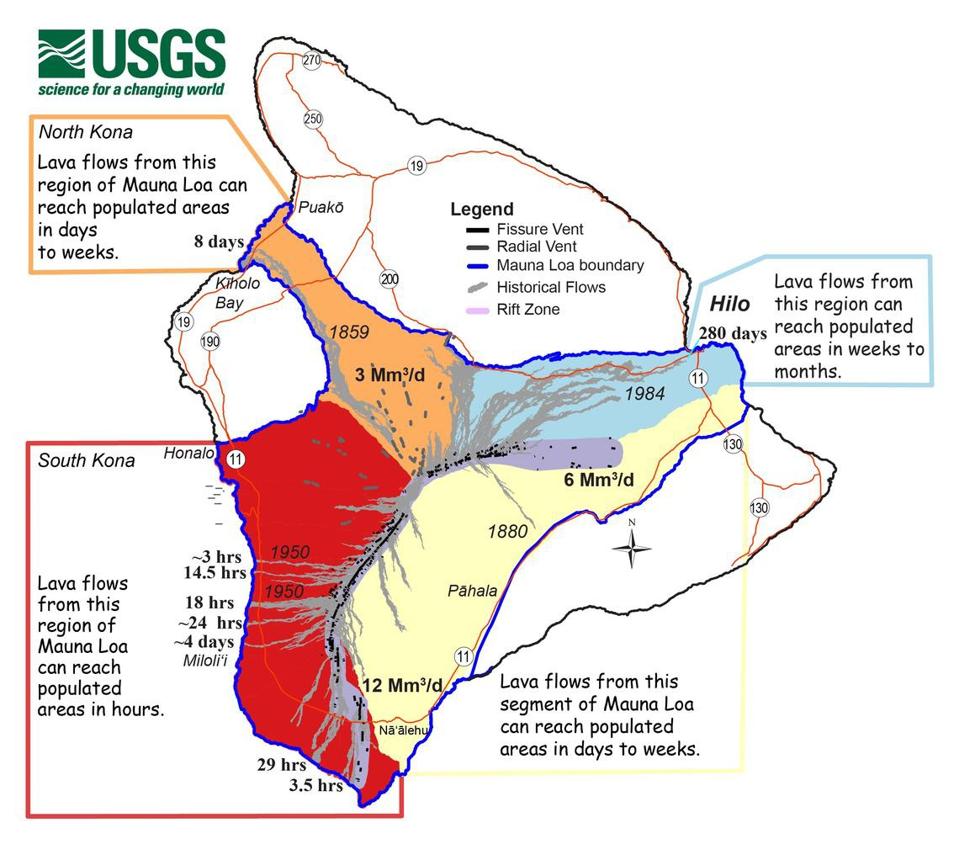
    I was lucky to be able to go on vacation to Hawaii once.  The morning TV news had a 'lava report' much like we have a 'weather report'.  TV personality stood infront of a green screen with a map overlay show closed roads due to lava, and it's projected path/speed.

    It was a really cool memory from the vacation.
Super impressed by the units used on that map: Mm3/d = millions of cubic meters per day
Edit: Largest average effusion rate is 12Mm3/d which is 138 cubic meters per second. So if that were all in a single lava flow it could be as high as a person, as wide as a football field and moving at 2+ miles an hour. And basically unstoppable.
Lisa Miura, Hawaii County’s real property tax administrator provided these answers:
The government does not claim ownership of all land covered by lava; the private property owner retains title even as the land’s assessed value plummets to zero.
As for that new oceanfront land? The state claims new coastal land created by volcanic eruptions. This ownership applies to lava flows extending seaward from the coastline — increasing the size of Hawaii island — not to those that cover the existing property.
There may be cases where the government eventually assumes control of private land inundated by lava, but it is not common practice. “If the property is abandoned, then eventually it could be sold at tax sale. However, we have not had a tax sale recently in this area as the values have been less than what was owed on taxes. The county and state have not been automatically assuming ownership,” Miura said in an interview with the Honolulu Star-Advertiser.
The government does not claim ownership of all land covered by lava; the private property owner retains title even as the land’s assessed value plummets to zero.
According to the county, Hawaii County does reduce or eliminate real property taxes for property owners within a lava inundation zone, and is doing so for those devastated by Kilauea’s current eruption, which has destroyed more than 500 homes in Lower Puna, Kapoho and Vacationland at this point, and made many more inaccessible.
How much is the assessed land value for fresh lava? The assessed value of the property would fall to zero for 2018, and the owner would pay no property tax, according to Miura. Any property assessed at $500 or less is exempt from property taxes, under a Hawaii County law approved last year. Presumably, such properties would continue to be assessed at $500 or less for years to come. And then, like some homeowners in Kalapana, rebuilding could begin for those residents willing to take the risk again.
One could write a good story on the premise of an alien race who comes to Earth after the loss of their home planet. The aliens then attempt to reactivate dormant submarine volcanoes to create a new continent for themselves in the Pacific Ocean.
Biologicals won't leave their solar system. The AIs that don't need biochemical metabolisms, caloric intake, gasses, gravity, etc. will.
Brains as we know it die, cannot replicate, and take years or decades to train. Hard drives can be duplicated and loaded into memory with no limit.
Biology and biological intelligence is a bootstrapping mechanism - a "hard step" [1] or two - leading up to the next stage in the evolution and proliferation of intelligence.
All of our science fiction centers on humans, because we write stories about ourselves and what we're familiar with. But that's just fantasy. The future probably looks nothing like what we portray in our films and books.
To slightly spoil a 20 year old book series, this is a variation of one of the alien conquerer strategies in Frederik Pohl's The Eschaton Sequence to subjugate recalcitrant planets.
You’d think so but we’re advanced enough to live in some of the most barren places on Earth — Siberia, Antarctica, the Sahara - but most people would surely prefer Bali or California (leaving aside community and social ties etc.)
If alien settlers arrive at Earth it will be more akin to what European settlers did to the buffalo than the Native Americans. Nuisance fuana to be pushed out of the way / eliminated.
Yep they likely will just wipe out any race intelligent enough to give them or their terraforming activities any issue. There is no reason to expect them to be nice to a species as primitive as us.
If an alien colonization fleet is in orbit around Earth, that's a fair assumption. They didn't come all those lightyears just to have tea and biscuits. They're not likely to just move on just because there are some buffalo already living there. We wouldn't.
It still depends - if you travel lightyears with a sizeable fleet just to capture a specific planet for living space alone, something is seriously wrong with your race anyway (unless you have some yet unknown transportation technology) as you could likely build uncountable space habitats for all that mass and energy spent & right at the heart of your civilization, not somewhere in the sticks with no friendly infra where Earth is.
You need a deeper purpose our you would not be there.
Would that also be the case if it was on private land? If my hypothetical private island had a few acres added to it from an eruption (can you even buy an active volcano?) , would it still be owned by the state?
Yes, all beaches and coastal areas to the high tide mark are public property according to the state constitution. Pretty much all coastal areas are already owned by the federal or state government and lava adding to it would just add to that.
Nope. You might have trouble getting there though. If there's no public road/easement to the beach, you'd have to get there by boat in order to legally use the beach.
Looks like he owns 98% of it, with the remaining 2% owned by the state, or by the few thousand inhabitants of the island. The 98% was already privately owned (pineapple plantation), he just bought that.
GeologyHub did a short video update on the building warning signs of a likely magmatic intrusion and possible lava flow paths a couple of weeks ago (based off USGS info). I always find his videos interesting and informative.
+1, and GeologyHub videos always seem very information-dense, brief, expert, and context savvy. Perfect if you want to be well-informed, with no wasted time.
Neat! Pele’s hair is a volcanic glass formation produced from cooled lava stretched into thin strands, usually from lava fountains, lava cascades, or vigorous lava flows. It is named after Pele, the Hawaiian goddess of volcanoes.
Yet again we see the big island of Hawai'i being "under construction". All the Hawaiian islands are made of lava from a single active magma hot spot. As the pacific plate moves northwest over this stationary hot spot, new islands are formed.
The Big Island (Hawai'i) is the youngest as it's over the hot spot now. The other islands have moved off the hot spot and no longer have active volcanoes. Among the oldest islands is Midway (yes that Midway) which is geologically part of the Hawai'i archipelago even though it's not politically part of it.
Keep in mind that the exposed area and volume of the Hawaiian islands is a very small portion of their overall volume. It is also worth noting that most of the volcanos in the Hawaiian chain are part of a single ridge which connects bellow the surface. [1] The depth of the ocean also differs significantly along the emperor seamount chain.
With all that said, This paper suggests that the rate of magma has increased recently. [2]
They're pretty young geologically, <5 mya. Hawaii gets insane amounts of rain, but its hard to imagine that being enough to fully erode an islnd the size of mauna kea, and i think you would expect to see similar volume between the islands if it were just erosion, since it would mainly just be flattening them, rather than dissolving them, but i'm also not a geologist.
My wife and I go to Hawaii some winters to celebrate our anniversary (it was our honeymoon spot, of course it was).
We've taken a few tours there to learn about the place. What I recall from those tours is that the islands are all slowly sinking. Indeed Big Island is the biggest because it's the newest - the older ones are smaller because they have had more time to sink / erode.
> 1.2 million years ago, Maui Nui was 14,600 square kilometres (5,600 sq mi),[1] 40% larger than the present-day island of Hawaiʻi. Sea levels were lower than today's, due to distant glaciation locking up the Earth's water during ice ages, thus exposing more land. As the volcanoes slowly settled by subsidence, due to the weight of the shield volcanoes and erosion, the saddles between them slowly flooded, forming four islands: Maui, Molokaʻi, Lānaʻi, and Kahoʻolawe by about 200,000 years ago. Another former volcanic island lying west of Molokaʻi was completely submerged, and covered with a cap of coral; it is now known as Penguin Bank.
Cold magma gets relatively quickly weathered by elements, so volcanic islands tend to go through process of creation and destruction on multiple levels. Only when foliage creates thick and cohesive enough layer to slow down weathering they become more long term (till new eruption swallows that foliage and here we go again).
Ie Iceland get from time to time new small islands created and they disappear by same process usually within few years.
So the good news is Hawaii isn't the "sudden explosion and everyone dies" kind of volcano. It's the oozy kind. You just have to not stand still and let the lava take you.
That's not to say it's risk free or that some people -- maybe even lots of people -- won't be homeless when the lava finishes flowing, but this isn't a high casualty sort of disaster.
Well, Mauna Loa has a fast moving lava in much larger quantities than the nearby Kilauea, so the scenario might be grim there as well. Large areas can be flooded within hours, especially on the south-west.
Thanks. I sent my friend a message because I’m not sure where abouts in Hawaii he lives. Hopefully he replies soon. But happy to hear it’s not high casualty disaster. Obviously no casualty is better tho.
It is probably going to be a no casualty event -- according to the USGS, only one person has died due to an eruption in Hawaii this century. Radios and cars make evacuations a lot easier.
I'm not even sure we'd expect casualties from the evacuation -- if 100,000 people (twice the population of Hilo) drove entirely around the Big Island (300 miles), you'd only be at around 30 million passenger-miles, well short of the statistical 1 death per 100 million passenger-miles.
FYI: despite popular misconception, "casualty" doesn't imply death. A casualty of war, for example, might actually refer to someone who is wounded/maimed/etc. but still survives.
If a house is consumed by lava and the occupant becomes displaced/homeless, it could reasonably be argued that it didn't result in zero casualties. Same goes for other things that might be more commonly understood as "collateral damage".
The island is huge, 70 miles East-West and 90 miles North-South. If you've seen islands on inland lakes, on the Great Lakes, or off the Atlantic or Pacific coast, you're thinking too small. As long as you're not standing on the summit of Pike's Peak (or Mauna Loa), you're probably unable to see beyond the curvature of the earth to a horizon comparable to the distance from the caldera to where your friend lives, and the probability that a lava flow oozes all the way to the horizon is vanishingly remote.
However, the bigger factor in your friend's safety is that the vast majority of the population live near the coasts of the island, very very very few live near the peaks. Also, 5x as many people live on the 5x smaller island of Oahu in the city of Honolulu rather than on the island of Hawaii...if your friend lives "in Hawaii", statistically they probably live on an island 200 miles away, or potentially on the coast 40+ miles from the summit, it's extremely unlikely that a random Hawaiian lives on the slopes of Mauna Loa.
There are a number of islands in the Hawaiian Islands spread over a fairly large area. (For commercial travel, you need to fly between them.) The biggest, where the eruption is happening, is also called Hawaii although locals refer to it as Big Island unless they're referring to the state as a whole. Big Island is 4,028 square miles (10,430 km2) and has a population of about 200,000 most of which is on either the east or the west coast.
Most of the population of the state though is in Honolulu on Oahu (also where Pearl Harbor is). There are over 100 islands but just 8 main ones of which casual visitors might visit 5.
> Mauna Loa is among Earth's most active volcanoes, having erupted 33 times since its first well-documented historical eruption in 1843. It has produced large, voluminous flows of basalt that have reached the ocean eight times since 1868. It last erupted in 1984, when a lava flow came within 7.2 km (4.5 mi) of Hilo, the largest population center on the island. Mauna Loa is certain to erupt again, and with such a propensity to produce large flows, we carefully monitor the volcano for signs of unrest.
Edit: The island is decently big, so the impacts probably won't affect a significant amount of the island. That said, some settlements like Hilo are in the impact zone for a significant event.
Decent doesn't quite cover it for people unfamiliar with the size of the state. The island that this volcano is on is bigger than the states of Delaware and Rhode Island combined.
Eruptions on the big island happen pretty frequently, maybe about 1-2 times per decade (partly because there are several volcanoes there; Kilauea was erupting when I was there less than a decade ago). It's in some ways comparable to hurricanes on the gulf coast, but with fewer deaths historically. Not to say that it is safe as such, but residents of the big island are very good at dealing with it.
Kilauea (the other active volcano on Hawaii island) erupted continuously from 1983–2018. It erupted, again, in 2020-2021, and is currently erupting as best I can tell. It is more notable when it is not erupting!
It'll be days before the lava is potentially dangerous. It's slow moving so plenty of time to evacuate. It can take weeks for the lava to make its way to the ocean
There are AQI sensors all over the island, but maunakea is 4000m tall and the eruption isn't really near anything other than the national guard base. Generally speaking the air on the Big Island is very very clean by most standards. In the typical trade wind pattern (which we are not experiencing at the moment) you will mostly see volcanic gas from kilauea get trapped on the south kona coast.
What exactly is the state of "volcano tourism"? I remember being entranced as a kid by footage of lava flows; the heat, the glowing, and the viscosity of it all just seemed so alien and exciting.
Do there exist – in Hawaii or elsewhere – experienced tour guides that can safely bring you to see such sights in person? Obviously I'm not saying I want to see the next Mount Saint Helens up close, but clearly camera men are able to get up close and personal, so there must be times and places where the risk is acceptable enough right?
I don't know about hiking up to see the lava on Mauna Loa (I read the area has been closed off for awhile due to a likely eruption), but when I was on the Big Island during a Kilauea eruption I took a helicopter flight over the lava flows. It was a great experience. I took one marketed as "Feel the heat" that had the doors removed. We did not fly over the main caldera but over some lava flows further down the mountain in the Puna district. I quite enjoyed it and I sure did "Feel the heat" when flying over the faster moving sections of the flows that were glowing red.
I was fortunate to feel the heat last year when I was able to get relatively close to the erupting volcano in Iceland. Sat atop a nearby hill that was accessible on May 31, but became inaccessible a few days later.
Mauna Loa is part of Hawai'i Volcanoes National Park, which you can visit. I don't think you get too close to the caldera, though. https://www.nps.gov/havo/index.htm
I actually stood on the Mauna Loa caldera once when there was no activity, there was an officially marked trail that goes down right to the edge of it and there were signs that say something like "you can stand here at the edge for a short amount of time but go no further!"
Although surely they close that trail off when lava activity is expected...
Fagradalsfjall in Iceland in 2021 was more or less a self-guided tourist attraction. I went twice a few weeks apart. Depending on the state of the flow there were different viewpoints and paths. There were a few search and rescue teams around during daytime hours, and some recommended paths, but I wouldn't call it a controlled area in any way. In general the lava flow was more than slow enough that you wouldn't be in any danger from it unless you did something incredibly stupid (and some people did, although I don't believe anyone died). In some of the valleys farther from the main caldera the lava was barely moving - if you were so inclined you could go and poke it with a stick. People brought hotdogs as a joke to roast over the lava. I imagine you can find pictures online easily enough, as hundreds of people were going up there every day.
I have done this. I don't know who would consider it safe, exactly, and from what I understand the trip was not entirely legal, but nobody got (seriously) hurt and it was an experience I will never forget.
We hiked out to the lava river in the pitch dark, starting off around 2-3 AM, and stayed til it was fully light. We saw a few helicopters after the sun rose but met no other hikers. We had two local guides who had scouted the route the night before.
It was spectacular and surprising, a truly alien environment. For all the hazards, I'd certainly do it again if I ever got the chance.
I went back to Kilauea several years later, on a boat - there were commercial tours which would take you right up to where the lava flow splashed into the sea. I was glad to see it from the other perspective, but walking up to the lava, getting right in there, and poking it with a stick, was by far the more intense experience.
You can still get close. During the 2018 Kilauea eruption a local took my partner in a flat-bottom aluminum skiff out where the lava met the ocean. Intense temperature and pressure deltas made the lava explode underwater, creating literal lava bombs below the water. The guide lowered a bucket fifty feet into the sea and pulled back a pot of boiling water.
Interestingly I am in Hawaii right now and hiked about 7 miles on Mauna Loa. It's part of a national park and it's massive- it takes about an hour to drive from one end to the other. I learned yesterday a volcano is more of a complex, the most recent eruption gives us the classic lava dome and crater you probably imagine when you think of a volcano.
As of yesterday there were no big fireworks going on, but there was lots of vents spewing steam and smoke. Apparently only part of the park is closed today and going at night you can see the lava glowing- we left before dark.
I've spent a few days in Volcano national park, right before the 2018 eruption.
We could see lava splashing in the caldera from an observation point (Which has been closed since then - not that it would be of much help, since the lava level has also dropped.) We could hike geologically active areas (sulfur vents), and across decades-old lava flows. The latter was an incredibly surreal experience, due to the sharp transition between dense jungle and alien wastelands.
There were hiking tours available for walking up to the lava at night, but they seemed pretty sketchy.
I did this around 2010. We hiked out to lava flows with an amateur guide being careful not to step on areas too hot where we would break through or melt our tennis shoes. I stuck a stick in flowing lava and played with it, slightly burning my hand. It is a lot like working with blown glass. We then sat on a nearby cliff and watched the lava flow from larger rivers into the ocean.
I assume it was illegal, but one of my fondest memories
Up until the recent Kilauea eruption in 2021 there was a period of about 30 years where you could hike up to molten lava flowing from the pu'u o'o vent on the southeast slope of Kilauea. The length of the hike varied from a few hundred yards to several miles depending on which way the lava was flowing. The 2021 eruption drained the lava from pu'u o'o and it stopped flowing, and the only exposed red lava was in the Kilauea summit caldera, and the only (legal) way to see it was by helicopter.
So the TL;DR is: it depends. At the moment it's not looking good for easy access, but stick around, the situation is bound to change. A week from now you might be able to see lava flowing in the streets of Kailua or Hilo.
This volcano's been erupting for 700k years. There are typically over a thousand potentially active at any particular time; 20-50 on any particular day. https://volcano.si.edu/gvp_currenteruptions.cfm
“The eruption continues at the summit of Mauna Loa. All vents remain restricted to the summit area. However, lava flows in the summit region are visible from Kona. There is currently no indication of any migration of the eruption into a rift zone.”
https://www.usgs.gov/volcanoes/mauna-loa/mlcam-mokuaweoweo-c...
https://www.usgs.gov/volcanoes/mauna-loa/webcams