A large majority of these elevations and building footprints donated to OpenStreetMap (over 900 Million) were contributed by Microsoft from Bing Maps. Microsoft now also incorporates OpenStreetMap data into Bing Maps.
Can someone give more context here? It's a cool 3D map, but this submission is at almost 100 points and I have no idea what it's about. Is this submission about...
- A private or open-source map visualization engine that's doing something new? (And if so, what?)
- A demonstration of all the 3D data already in OpenSourceMap? (Has it made a leap forwards or something? How complete is it?)
- Something else?
Is this something new and newsworthy or just somebody re-posting something that's been around for a decade? I'm just totally lost here.
It's obviously not complete. I took 2 locations that I know well (different countries) and the first has relatively realistic looking 3-d building shapes. The other has nothing.
And that it's using a 3rd party engine. Since the OSM data is "open", there's nothing wrong with making use of it.
I don't know about this project, but OSM data included information on levels for a while (and it was used, in addition to just being there: e.g., in JOSM you can switch between levels for editing; not sure if I saw 3D rendering of OSM data before, but that's possible). While this looks like a demo by a commercial company selling "Interactive Map Solutions": not major news about OSM itself, but may be amusing to poke.
This is great but one thing worth noting is it doesn't have 3d topography, which is pretty critical if you are looking at the world in 3d in many areas
Height is wrong for my home. Seems to be absolutely random. Some buildings are literally intersect. It's fun visualization, but I hope that nobody would use it to get any data.
I noticed the height of quite a few buildings in Ft Worth, Texas is also wrong. A number of buildings are way off. I made an OpenStreetMap account to leave a note but decided that was not the way to go about reporting that type of issue since this appears to be a separate product built on top of their work so I didn't leave anything.
Anyway, nice job. I also could not find a way to see things using a satellite overlay. Maybe I didn't click enough buttons.
Side note - The symbol used by OSM for trees causes the area around my place to show palm trees. I thought that was funny. I live on a rock outcrop and I think you would need to hire a tree sitter to keep a palm tree alive near my house. I understand the symbols are generalized. That was funny though.
> I noticed the height of quite a few buildings in Ft Worth, Texas is also wrong.
They render buildings that are missing `height` or `building:levels` data in OSM with 3 levels by default. So you could add this data to OSM to make it render.
I will have to explore the process for updating those features now that I have an account. I read the how-to section and it looks like a process where a new user would submit a potential change and other experienced users would dissect the change to determine whether anything would be broken before applying it.
Thanks for the clue about which attribute to search for.
I've just browsed for a minute, and aesthetically, I think the trees/grass/water try to be realistic and they're too high-frequency for them to be pleasing IMO.
Flat colored trees and grass, and simpler water shading would make everything more cohesive. It's like some things are minimalist / low poly looking (buildings, roads) and others try to be realistic (and kind of failing) and they don't fit.
I'm wondering where it is getting the data for the high-resolution buildings?
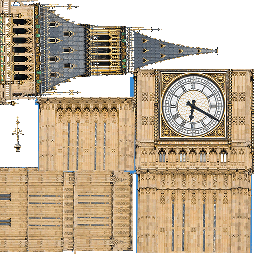
For example, Big Ben at the Houses of Parliament in London has a detailed model, and so too does nearby Westminster Abbey, and several famous structures nearby.
It looks quite impressive; guessing the server is getting more traffic than it's designed for (and it doesn't seem to cache tiles, at least not partially loaded ones, maybe?).
Is it normally significantly slower in Firefox than Edge/Chrome or is that just my b0rked up daily browser?
All I'm getting is a message: "Oops! Unauthorized F4map API usage. If you are this website administrator, please contact the support at support@f4map.com."
The compass button slightly confuses me. I thought the arrow in anticlockwise direction was intended to turn the map anticlockwise, but it actually works like a GPS navigator, i.e., it works as if I turn my car to the left and the direction ahead is always the upward direction on the map.
Interestingly, this does not trigger the automatic graphics switching on my laptop, which I take to mean that this is not using webgl but rather is doing the rendering in software. Is there any information on the technology used for this?
It's cute, but at least in Amsterdam it seems to have no idea how tall most buildings actually are, and uses random heights. On streets where all the buildings are the same height, the map makes it look like a lively bar chart.
Not quite. Some buildings are different heights and some even have multiple levels. Obviously nowhere near what Google Maps does now. More like what they were doing 10 years ago. Still cool though.
Only if there is no additional information. Most buildings have polygon on ground level and height/number of levels.
It's possible to make more complex shapes
https://github.com/microsoft/GlobalMLBuildingFootprints/
https://wiki.openstreetmap.org/wiki/Microsoft_Building_Footp...