If this gets enough traction this could make historical maps so much more accessible. Instead of every historian writing their own magnum opus of a particular area and timespan, all the geographical information can be combined in a single system. Is there a system built in for keeping track of annotations/sources? How are debated topics/unresolved locations dealt with?
What if different schools of thought exist for where something was in the past, could multiple hypothesized locations exist for a single object? Direct link with Wikipedia would also be useful
Very nice project, hope it becomes as useful and detailed as the present day OSM
There is already a super accessible presentation of history maps: Paradox games like Europa Universalis, Hearts of Iron, etc. The games achieved what you’re talking about already, there’s already an old, large and very active community of modders across their games that make historical accuracy (or gameplay-favorable inaccuracy) changes. It’s possible the mean Europa player, over all the games, individually spent more hours looking and interpreting the historical map in those games than anyone has ever spent looking at any Open Street Map property ever.
If you’re thinking about contributing to OSM History maybe consider EU4 instead. Maybe you think these are different things. I don’t. One satisfies your curiosity (ie entertains you) a lot better than the other.
Maybe though OSM History could be a place, like Wikipedia, where people could settle “territorial disputes.” I don’t know, that shit, wherever it appears, is a pretty toxic part of any community. I’m not 100% sure how Europa deals with it - you can download whatever mod you want, after all, it’s your game. But my feeling is, most of this territorial dispute shit hardly affects the people talking about it at all, and the feelings of playing a video game and all that entails - positive feelings - are better than the negative ones you feel when you’re pursuing what you believe is justice in a Wiki talk page or a Twitter flame war.
I think this is a pretty key question that also applies to any effort by any other commercial provider. The detail in the historical models in EU4, any of Ubisoft's games, etc., is fantastic. I'd love to see any of them make stripped-down versions of their geodata available through open data licensing. Maybe there's something we've missed in the EU4 modding that could be of use? We'll take another look!
> Instead of every historian writing their own magnum opus of a particular area and timespan, all the geographical information can be combined in a single system.
Isn't that true of all historical data? It seemed so obvious to me that professional historians would share data that I asked several professional historians what the standard format was. Nobody had even considered it, as of ~10 years ago.
Obviously you can't structure all historical information, but you can do a lot of it: Location & time, other things present at that spot in space-time (people, events, weather, diseases, governments, etc. etc.), and sources. And then some unstructured fields, including one for analysis.
I'm sure that's misguided, as I'm not an historian, but it sure seems like much more value could be extracted from research if it was accumulated and shared, and not stuck in someone's personal storage, and that it would save a lot of duplication of effort.
You're right on. I've asked many for shapefiles of the world's historical boundaries & some do exist, but are often encumbered by copyrights / licensing that add friction to sharing. Our goal is to have as much CC0 data as possible, although we have added some CC-BY-SA-NC data. All data is copyright / license marked at the object level, with no label defaulting to CC0.
"What if different schools of thought exist for where something was in the past, could multiple hypothesized locations exist for a single object?"
How to represent such things on a map can become quite complex very fast. A placename from an old document may refer to multiple locations, but these are mutually exclusive. The probability of attribution may vary in each case. Different scholars may disagree about these probabilities. Etc, etc.
> Instead of every historian writing their own magnum opus of a particular area and timespan, all the geographical information can be combined in a single system.
The two options are not mutually exclusive: Dr Shmoe and Dr Kroe can write fascinating books on the movement of the border between Hannover and Braunschweig that mostly agree but disagree on a couple of fundamental points; both could be represented, and perhaps compared, via different views.
For an existence proof: Wikipedia is able to have decent articles about (some) subjects where strong consensus does not exist.
Thanks, @tda!! That's a very kind and optimistic post. I think everyone in the OHM community is working with good intents to create a rich resource available for easy reuse and download.
You hit the nail on the head about trying to combine various different geo/temporal efforts to provide greater context of world history.
Our tagging system is like OSM's - very flexible - with all the strengths and weaknesses that offers. And, the tagging system has limitations that we're currently working through & around.
One strength is that any object (node, way, relation in OSM-speak) can have multiple sources. e.g. source:1=url1, source:2=url2, etc.
And, tagging areas as disupted=yes is pretty straightforward.
bit.ly/disputedUSA
We have yet to hit any sensitive areas of debate, but I imagine that will happen in the not too distant future. OHM's system is inherently vulnerable to vandalism, but the goal is to allow conflicting perspectives to coexist, as long as they are sourced.
The current system from e.g. Google is pretty weak IMO, it's made to not piss the sides off, so if you load up Google Maps in Pakistan you see the disputed territories belonging to Pakistan, and in India you see them belonging to India. But if it's the stuff of history it would be interesting to display the areas overlapping each other, or to mark that there was active conflict over the territory at that point in time.
Being Dutch and a history-buff, I have one mayor gripe with historical maps, that sees land as 'moving lines' on a fixed map. When I look at a historical maps (also in books), I often see the Netherlands represented in it's current form, i.e. containing land that is not even 50 years old, being prestent hundreds or even thousands of years. I get that it is an intricate history, and maybe too much effort in some cases, but please at least remove flevoland. https://en.wikipedia.org/wiki/Flevoland
It's true, and it is not just a Dutch problem. Basically all major river systems change throughout the centuries: meandering arms evolve and others get cut off; river deltas grow and change shape and of course human activity shapes the landscape (canals, irrigation, drainage of swamps and floodplains etc.). The ancient city of Eridu for example was a coastal city around 5000BC and today lies hundreds of km inland.
I've recently been thinking about this with regards to borders. There are plenty of borders around the world that rely on rivers as a boundary, but river's aren't static, and meanders shift all the time.
Of particular interest to me was the England/Scotland border, as I was visiting the area, and noticing that it doesn't always follow the path of the river Tweed.
When a river is a border, that is by nature always changing, how do countries decide which bit of land/islands are sovereign?
It seems like this is adding some vectors on a gridded base map. But OSM has every object in a vector form, also coastlines etc. So I don't think there is a technical reason why coastlines would have to be fixed for a historical map. On the timescale of ages and millennia, rivers in delta planes are also usually not very static.
Well... coastlines are handled in a deep, dark, arcane part of OSM planet and data processing, but you're right. Rivers, on the other hand should be straightforward to change. We'll have some cleaned up examples in the near future.
Not only deltas, any river meandering over any plain will change its course pretty "quickly" (which creates problems if such a river is defined as the border between two countries BTW)
I live in the Fens in England and noticed the same thing. You can set it back 1000 years and not only is the Fens still drained, there are artificial drainage channels that weren't dug out for another 600 years. It seems an assumption has been made that rivers and coastlines don't change over time but it's so far from true! For me it's one of the most interesting, and scary, things when looking at old maps. Does the data model support changing natural features like rivers and coastlines?
Yes any feature as far as I'm aware can have a start date and end date so can show the changes over time. As can be seen in London (https://www.openhistoricalmap.org/#map=16/51.5108/-0.1086&la...) where the shape of the river changed when the Embankment was built in 1869. As far as I'm aware there is no reason why changing coastlines couldn't be mapped, though it is a lot of work to draw in a long length of coastline.
I personally also find https://hisgis.nl/ an interesting resource, especially if you want to know about the 1832 kadaster maps, which are far more detailed that the maps that topotijdreis shows of that period. I do not know if this is available for the whole of the Netherlands, but the maps of Overijssel are available.
View a variety of historical maps on the left, with the same area "now" on the right, with the pointer synced between the two sides so that you can trace roads, building outlines, etc.
Neat! On zooming in on the UK, I landed mostly by chance on Gatwick Airport, only to discover that it's built on the site of a former racecourse. A quick web search brought me to the Wikipedia page with a potted history of said racecourse, and how Gatwick has named various features after it. Fascinating.
I would suggest that, if various portions the vectors could cite evidence, it would be an excellent basis for historic vector maps on Wikipedia. Currently, this whole area is a shambles.
Further, I recently learned some historical maps I had created with great effort for my Tang Dynasty text translation at https://en.wikisource.org/wiki/Translation:Manshu were deleted by some Wikipedia policy-thumber who reckoned including low resolution satellite backgrounds to contextual maps was grounds for erasing them. You'd think being an open source project for academic caliber translations you'd be able to use, you know, open sources under academic fair use. My tolerance for idiots is truly at an all time low.
The notion that there is a fixed line between cultures is itself a farce, but, historically the majority of such maps drawn for empires are written using the implied borders from latter-day interpretations of geography that was mentioned by an eventual victor as annexed. However, the reality on the ground is usually much different. In some cases, thousands of years different.
This is a difficult thing to describe for any pre-modern polity, where vassalage and weak frontiers make it difficult to describe if a central power actually controlled a territory. The Ottoman Empire de-facto exercised little control its North African vassals, the Roman Empire had increasingly weak control over its frontiers due to migrations and incursions, etc.
There's a lot of great work in Wikimedia commons, but I think there are 2 primary / very common issues:
* Format - many of these maps are .svg or illustrator-created images with no projection information, which makes data extraction very difficult. This is why we're trying to share with GIS-formatted data, so people can do with it what they'd like.
* Sourcing - very often, a map is depicted with a source of "own work". That, unfortunately, really isn't good enough & we're trying to source all objects in OHM. What's scary is that putting something in Wikimedia almost ensures wide propagation as "fact", even if it lacks a source. Here's an example... the base map is sourced, but where did this red line come from? It appears to be hand-drawn on a map... who drew it? How'd they get that outline? https://commons.wikimedia.org/wiki/File:Comancheria.jpg
Relatively accurate projection detection should be feasible for some, particularly vector, maps. Perhaps a library for this could be made. A simple approach would be convolution of nearby topographic features by assumed potential projection and then a least-difference comparison with observed positions. I am sure the CIA foreign map processing people have had this stuff for decades already.
I have a relative who has been spending years collecting data from archives and building historical maps of Ostrava, a city in Czech republic [1]. He built nine (9) time based layers (1860-1940). The amount of time and work this takes is just incredible.
He has been considering providing data to OHM, but obviously has not been convinced by this prospect yet, one of the reasons has been loss of control over his data, as there are academic institutions ready to snap this a put their name on it. It was already attempted.
I can imagine there are more researchers like this and the results of their work, all the data, is fragmented somewhere out there... and possibly lost.
These are mainly links to georeferenced raster images and databases, not vectors / OSM data. But, still -- I've already spent hours browsing old maps of my home city. For anyone interested in contributing to this project, oldmapsonline might be a great reference.
This is cool. For my hometown Berlin I love to browse this map https://1928.tagesspiegel.de/ it shows Berlin in 1928 and most areas are still the same.
Yeah, it's very intersting indeed. Roads and street layouts usually don't change that much over the centuries -- they get integrated and amended, but seldom disappear. I was pretty amazed to recognize the street layout of Leipzig in the 1740ies: https://biblio.unibe.ch/web-apps/maps/zoomify.php?pic=Ryh_53...
Fascinating stuff. There were some attempts with e.g. Yahoo's Geoplanet to take historical context into account. I know some people who are still working on that data set (which Yahoo released under a creative commons license): https://spelunker.whosonfirst.org/concordances/woe/
I live near a building in Berlin that has a sign "this building used to be in a different country". Also, I live on the only street still intersected by the wall. It's Bergstrasse which is intersected by the wall memorial. I remember listening to the news announcements in the Netherlands when the wall fell when I was a teenager.
Another interesting thing is that borders are kind of imprecise. We've only had GPS for a few decades and most maps predate the existence of that. Land surveillance to modern standards pretty much developed only in the last 200 years (e.g. Ordnance Survey in the UK is one of the older examples of an institute specializing in that). Post colonial dividing up of territory in e.g. Africa was done with rulers without too much regard for history, culture, or ethnical divisions. The border between the US and Canada is similar in some places. Also internal borders for some federal states are funny like that.
Besides, stuff moves around on this planet by centimeters per year in some areas. The meridian does not actually run through the little monument they have in Greenwhich for that (by over 100m). It hasn't for a long time. Rivers, which are commonly used for borders, move as well. There are some minor border disputes all over Europe (and a few major ones) as well as occasional pragmatic agreements between e.g. Belgium and the Netherlands on how to administer certain regions. Baarle Nassau of cause being the most surreal example where we are talking exclaves, enclaves and enclaves containing enclaves, etc. Some houses cross borders and have entrances/exits in different countries. It's completely nuts.
Oh wow. I am literally slowly working on something like this as well. But my knowledge of mapping technology is very limited.
My focus was actually much more on trying to use partly public data, and partly contributed data in order to 'render' information on top of such a map. My vision was basically to have all historically known people and there locations being visible on the map. Wikidata already has a nice start to this, but you would need a contributor model to flesh this idea out quite a bit more.
Another step after that would be the movement of armies. This could be really interesting if you could see armies moving around at different times and getting closer to each other, or pass each other by.
City population is another interesting thing. There is no easy way today to get a good estimate of what some city X population might have been at any particular period. That information is buried in all all over the place.
There are many more ideas, but having his historical map is actually awesome for me, because that was the part that I know least about. So it should be an amazing piece of the puzzle.
Cool project! Too bad there's not much detail in these maps. The Dutch land registry and national mapping agency maintains a website with highly detailed, historical maps of the Netherlands that go back to 1815: https://topotijdreis.nl/
Immediately thought of Europa Universalis IV and all its expansions :-)
However so much potential for abuse and misuses .. just think of all the border disputes currently countries are having and multiply those by all the years
That's why I mentioned the OpenStreetMap relation ID, with that you should be able to pull the OSM data and there are usually tools to convert OSM data to whatever you need. What format do you need it in?
Tell us more - is having to sign in to edit a barrier? Should we rethink that? (also, I've made a note to fix that... I believe that was from an old ThinkQuest dataset. TY!)
This reminds me of the nascent stages of a very similar project I designed a few years ago[0], that sadly never was able to get traction (unrelated to the concept) ..but the idea at the time had a lot of vision and potential.
Glad to see it reinvigorated especially in the age of misinformation and white-washed historical data.
If the UI/UX, social-graph, and collab features evolve to a much more polished level, this could really attract a new generation of younger researchers who would really be able to scale it up.
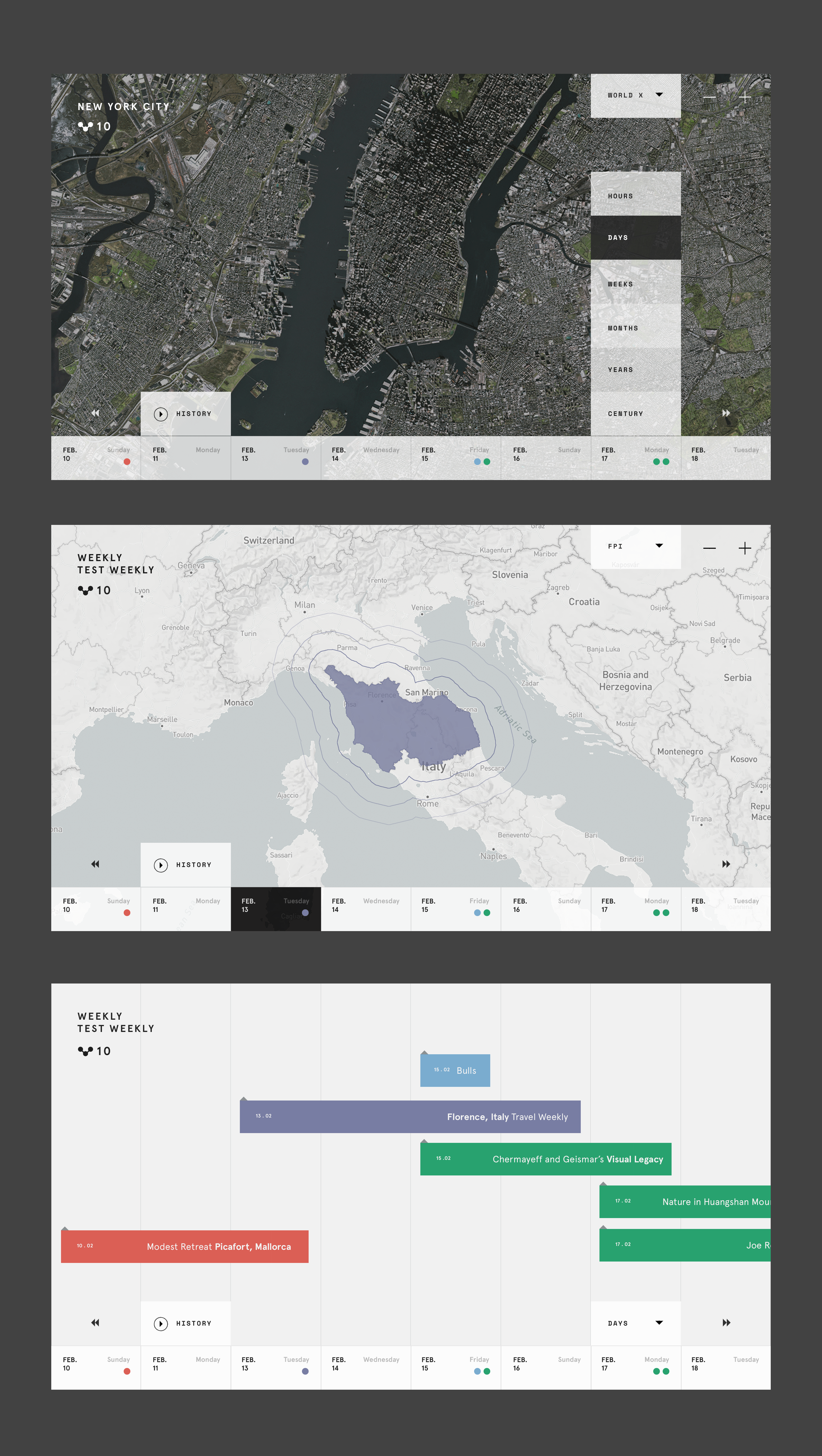
Here is a sample UI/UX [1] of what a well designed timeline could potentially look like.
Looks like they've added a start date and end date field to existing features of OSM. Couldn't this just be fed back into the existing OSM database?
We could add dates when pubs opened. Then when they shut we can add their closing dates; adding to the historical record and they could then be removed from the OSM map.
I am quite bad at history but quickly looking at central Europe this project seems to have some inaccuracies.
- I couldn't find any mention of Prussia [0]
- during years 1920-1938 the borders between Czechoslovakia and Poland are messing so it looks like it is a single country
I am sure anyone can find what is missing/wrong with the history of their country. This is a community project after all so I am not surprised but based on Wayback machine this project started at least 7 years ago.
It tends more to be things which haven't been mapped yet rather than inaccuracies as such. Most mappers have concentrated on mapping their local town or city rather than national borders. See Kiev (https://www.openhistoricalmap.org/#map=16/50.4633/30.5218&la...) and London (https://www.openhistoricalmap.org/#map=15/51.5163/-0.0900&la...) for example. While the project may have been going a while, it was only last year that the time slider was introduced which made it properly functional as a historical map. At the moment there are still few mappers (including myself) but I get the impression that OHM is now beginning to develop more quickly!
Yep - we've just started getting some traction. I would expect that we'll have Europe from 1800-2021 done within a few months. Perhaps you would like to join in?
Separately, missing data is different from inaccurate data, no? I'm sure we have many inaccuracies, as well, but we're working to fix those.
Cool project! Hope they get a lot of contributors - they are definitely going to need them, already in the default view I can see a lot of room for improvement: in most of Romania they still have the Roman/Greek names in 1850, Serbia is shown as "Servia" (as it was apparently called by the Romans?!) etc.
Oh, nice. Setting the date to 1800 and looking at Boston shows the "pre-fill" coastline, and even the fort at Boston Neck. No roads, though, and Logan Airport's land wasn't filled in in 1825, but it is editable.
Nice initiative but sure it will cause many many user conflicts, especially for locations where the boundaries are disputed. I hope we don't see comment wars here in HN about different regions.
Borders are still disputed today, so any issues that are relevant would also exist in the OSM maps. I'd heard that Google shows differing borders depending on where you're viewing from, not sure if OSM do the same.
Of course there are plenty of borders in history that are always going to be debated. Those are academic disputes though.
OSM is showing what's on the ground so there are no dotted lines like with Google Maps. For example both the Golan Heights and East Jerusalem will be shown as part of Israel because it is the de facto ruler of those areas.
Love the idea. Just made a note to self to try and add cape cod canal data, as I just checked and it has the canal there far before it actually was dug.
Plus another counterexample from the opposite side: Andorra hasn't changed its borders since 1278, but only became reasonably rich in the second half of the 20th century.
I don't think so. I have worked in the Germanic side of Switzerland before the pandemic and will go back after it.
IMO the main reason is that Switzerland has no natural resources so for this reason it was not invaded. You go to Africa and see the same thing, the less resources a country has, the wealthier it is.
Then you have Jews and protestant ethics in half the country that value work a lot. They welcome and support you if you are a good worker.
Then you have cold Winters that develop indoor activities like reading or workshops. They used to sleep half of the year.
But the most important thing of all, they don't have socialist or communist in power. It is a great thing that I can not vote, because the majority of workers that go there to work are leftist and will destroy the country in a few years if they could vote.
Imagine that you take the better workers, teachers, and entrepreneurs in a country and exterminate them. That is what happened in Russia and China with the communist revolutions. The most lazy and envious, aggressive and worst workers became the bosses.
That made people in those countries to literarily starve to death from incompetence and population to go down(Russia population was bigger than US of A at the start of the century). But most important, it was an inverse natural selection. The brightest and resourceful people disappeared from the genetic pool. And the culture destroyed excellence and hard work as a merit.
In Switzerland, merit culture not only survives but prospers, because without natural resources, they don't have alternatives.
Why do I have the urge to tap the satellite view button. Common you game developers from Flight Simulator. Given some references one could fake this really nice :)
But joke aside. I think this is awesome. Does anyone know how accurate the borders are in the German area when changing years?
I hope this gets more contributors, as it could be quite useful.
I wonder how difficult it would be to build some kind of `OpenHistoricalStreetView`. We certainly have enough historical photos to do something interesting.
Awesome idea! I was thinking about something like this too for a long time, though it's currently in a mental box labeled "probably not in this life" for me. As others in this thread mentioned, there are quite a few interesting challenges that would probably need some experiments how to resolve in the future, though I totally do think "starting small" from a somewhat simplified prototype, and then hopefully iterating, is most certainly the only possible way to do this. Summarizing/expanding on some challenges I've seen noted by others in this discussion, and adding "a few" of mine that I randomly pondered sometimes (while not even being a history buff):
• although (IIRC according to something I've read recently) land surveying was practised in established "countries" since at least babylonian times, I believe there's quite a few challenges to the notion of "firm and precise borders"; going kinda back in time, this can include:
- access to precise survey data might not be easy even in modern day, with this getting harder and harder + lines more and more blurry the further we go into the past;
- as noted by others, some borders and territory ownership is heavily disputed even in the modern day;
- during wars, this gets even more unclear kinda by definition (a lot of "we control this territory" can change as frequently as many times a day, and is anyway often vaguely somewhere on a spectrum between "fact" and "wishful thinking"); [as a side note, I was kinda thinking it would be even more awesomesauce to show army movements and other population data on such a historical map as well, however this adds a whole new universe of complexity];
- a notable subcase of the above points being "deep state" situations, where the official country's officials might have a varying (sometimes tiny or none at all) authority over some parts of their territory, controlled e.g. by organised crime;
- in less "organised" countries (incl. more "primitive/aboriginal" ones), I suspect land survey might sometimes not exist at all; and/or, it may be based on some rather different cultural notions of "ownership" and "borders";
- in fact, AFAIU, the notion of "countries" is kinda something that is not a given at all historically; I believe throughout history something resembling a feudal model (or a kingdom) is much more prevalent, i.e. "I [a king] claim to be owner of this land", where I would imagine it's much too easy to make such claims; and then, with all what I wrote above, even looking at "de facto" ownership and fairly "organised" kingdoms, based on just some pop-historical literature I believe especially the closer you got to a "border" between the kingdoms, the more it resembled permanent "war territory", with "quick border raids" etc. and local skirmishes being so obvious, that nobody could even imagine it might look different in the 20th+ century (with things like The Chinese Wall and Hadrian's Wall being kinda monuments to that reality); for another possibly nonobvious organisation model from modern point of view, see ancient Greek city-states;
• time tracking being very different (e.g. "king X's Nth year of rule") and sometimes tricky to map to a universal timeline, such as the "AD/BC" (a.k.a. "CE/BCE") scheme (e.g. can we pinpoint the start of "king X"'s rule based on available sources? was it even a real king or is it purely a mythical figure? do all the sources claim the same X and N?);
• as others wrote, natural land borders & shapes definitely moved & changed over time; this can include but is not limited to:
- rivers (see other comments); artificial islands; volcano islands; volcano "mountains"; dams; floods (incl. permanent floods into land-locked depressions); drying lakes/seas (see e.g. Dead Sea, Caspian Sea);
- ice, incl. the "ice ages"; maybe a stretch case, but IIRC the Baltic Sea is known to have frozen in historical times, to the extent that inn(s) for travelers crossing it over the ice were built on that surface [though "citation needed", i.e. I totally did not fact-check it];
- go far enough in time, and continental drift itself becomes clearly apparent; this means not just broken landmass continuity or new landmass connections, but also new mountains (which often tend to become natural borders).
And that's just off the top of my head ;D I think stuff like this makes such a project super interesting and novel! :)
Also 1800s has good coverage of sources. Like this one in Europe: https://maps.arcanum.com/en/ (actually this one is probably licensed - but some of those maps have public domain version).
What if different schools of thought exist for where something was in the past, could multiple hypothesized locations exist for a single object? Direct link with Wikipedia would also be useful
Very nice project, hope it becomes as useful and detailed as the present day OSM