Hold up, the title is "The Places in the U.S. Where
Disaster Strikes Again and Again" but the first map they show is "Losses in each ZIP code from major natural disasters, 2002-17" in 2017 USD. This is really misleading because the a zip code could have one disaster and show up on the map. It would seem a different type of map that actually shows "again and again" would be much more appropriate.
And since it's based on value, this is highly related to the number of people living there. There could be a perpetually-erupting volcano where no one lives and it wouldn't show up at all.
Not exactly. This maps shows insurance claims related to natural disasters, not incidence of natural disasters. Big states out west have very low population density as compared to spots east of the Mississippi. If a raging forest fire or severe storm happens on a big stretch of BLM land in Nevada, nobody's going to make an insurance claim about it.
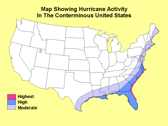
That was my impression as well. While hurricane prone areas are highlighted well, once you move out of those areas, the map seems to start correlating to population to a large degree. Granted there are some cities missing and and some rural areas as red spots.
Most of Nevada is downright uninhabitable or very close to uninhabitable and resource poor. It’s mostly owned by the US government and completely barren of water and plant life. Basically, it’s as though the great disaster were an everyday thing-and actually somewhat stable in its constant dry heat. Pretty sure it was largely that way in pre-US times.
Now that's just uninformed. Yes most of it is BLM/USFS land, but there is definitely plant life, it's desert, some of it high desert, with snow in the winter and everything. You can have 70 degree weather in the summer in NV if you know where to go.
That said, there is definitely a reason Nevada is the place they tested a bunch of nuclear weapons. :)
Northern New England is in general a pretty safe place to live, as long as you can deal with a little bit of snow or an ice storm once a decade. There's water enough that forest fires are a rarity, tornados are very rare, hurricanes usually have played themselves out by the time they make it this far, and there are no volcanoes. There are earthquakes pretty frequently, but they're such small magnitude that I mistake them for the Amtrak going by[1].
Hahahah, that's great. I actually found out about the earthquake before it happened, on Twitter, so I actually knew it was an earthquake, but still. Had to check the date though, I didn't think it was 6 years ago, felt more like 3!
Yeah, Oregon hasn't seen a meaningful earthquake in most anyone's memory, so it isn't high on the list to prepare for one that might be coming, or not, in our lifetimes. Definitely want to avoid the area if you're averse to that risk...
Strangely, it seemed to mostly affect the run-down part of town that was due for redevelopment, and completely destroyed the local gay bar (The Sun) which was the last business hold-out resisting the gentrification of the area.
Apparently the weather-modification tests of the '50s and '60s are bearing fruit.
I’d be interested to know if anyone living in these areas has had trouble with insurance rates over this period. I realize many people aren’t fans of insurance but some of these areas seem quantifiably troublesome to live in short term.
I live in one of these areas (Huntsville, Ala., the red blob at the top of Alabama).
Here, it's tornadoes. But the thing about tornadoes is that they are incredibly localized. While the big mile-wide wedge tornadoes are can destroy a lot of property, most tornadoes are small - a few dozen to a maybe a hundred yards wide. And even the big ones affect, relatively speaking, a small area.
A tornado could destroy your neighbor's house and leave yours almost totally undamaged. The real danger is when you have an outbreak of a bunch of tornadoes hitting the same area. Even then, though, any individual person's chance of being impacted are pretty low.
That said, I haven't had any problems getting insurance. Although, after the 2011 Super Outbreak [0] my insurance went up about 20%. Which sounds like a lot but was about $200 a year increase or $17 a month. Hardly breaking the bank for me, but I can understand how it might for some.
Assistance can include grants for temporary housing and home repairs, low-cost loans to cover uninsured property losses, and other programs to help individuals and business owners recover from the effects of the disaster.
Will return when I have more information. I am active in the public policy space outside of my day gig, and flood insurance is an issue near and dear to my heart with regards to wasteful federal spending.
I had a relative who's home flooded during Harvey, used the Federal flood insurance to rebuild and this year renewed insurance at the same rate. Flood insurance is out of whack with normal insurance practices.
My father and brother's houses 6+ miles apart. Were destroyed by the same tornado in 2010. Neither had any insurance issues at all (fortunately, didn't happen for everyone).
Tornadoes while scary don't typically cause enormous areas of disaster on the scale of a major earthquake or hurricane. Flooding causes more issues as well.
Relevant xkcd [1]. The map would be quite a bit more informative if it was normalized by the value of all assets in each region. Population density could probably be used as a first approximation if such information is not [easily] available.
One the one hand, yes. On the other hand, you don't need to normalize anything to see that we should probably stop classifying hurricanes as "natural disasters" and start calling them something that indicates what they really are...totally-expected extreme weather patterns.
It's not about what you want to call them, it's about producing a meaningful map. If you want to show where disasters regularly occur and you want to use the costs of the damages as a proxy, then you have to normalize it, otherwise you may just produce a map of the value of assets.
That's possibly the dumbest chart I've ever seen. Since when are nuclear plants disaster locations? Might as well label the entire US at risk of "falling airplanes" or every city as "ICBM target".
In going to assume this just an ad for the labeled data center which is right in the middle of a drought prone area. Can't run a data center when there are no employees and no water but I see that droughts and wild fires are conveniently omitted...
Not to mention that 100mi inland doesn't have nearly the same risk for dangerous hurricane effects as 1 - 10mi inland, and what about forest fires, and what about icy roads, etc, etc.
In places where winter weather is normally cold and snowy, big storms aren't really disasters. It's necessary to plan for them but it's very unusual where just being in a location during one exposes people to a lot of danger.
One risk in that case is if there's a heavy, early snow before the leaves are off the trees. That's really hard on trees, which is really hard on the power grid.
That happened in Connecticut in 2011. Heavy wet snow the Saturday before Halloween. We were without power for a week.
It's a simplified "risk map" that appears to be made by [1], who (vaguely) cites where they pulled the information for earthquakes [2], tornados [3, 4], hurricanes [5], and nuclear facilities [6]. The map is not meant to imply that "nuclear = bad".
I'm more of a fan of the version without nuclear facilities. After a little digging, the original intent of the map's creator appears to be to emphasize nuclear facilities' relationship with earthquake risk to sell a product, which is somewhat disingenuous given the statement here [6]. I'm not affiliated with this group, and could have been more careful selecting a source.
I posted the map as an attempt to summarize information related to the posted article, because the information is generally consistent with the more refined maps the article displays (although does not speak to financial impact).